Laflin, Pennsylvania
Laflin, Pennsylvania | |
|---|---|
Borough | |
 Municipal Building | |
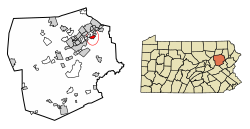
 Location of Laflin in Luzerne County, Pennsylvania. | |
| Coordinates: 41°17′25″N 75°47′34″W / 41.29028°N 75.79278°W | |
| Country | United States |
| State | Pennsylvania |
| County | Luzerne |
| Region | Greater Pittston |
| Incorporated | 1889 |
| Government | |
| • Type | Borough Council |
| • Mayor | William C. Kennedy |
| Area | |
• Total | 1.31 sq mi (3.40 km2) |
| • Land | 1.31 sq mi (3.40 km2) |
| • Water | 0.00 sq mi (0.00 km2) |
| Population | |
• Total | 1,451 |
| • Density | 1,106.79/sq mi (427.28/km2) |
| Time zone | UTC-5 (Eastern (EST)) |
| • Summer (DST) | UTC-4 (EDT) |
| Zip code | 18702 |
| Area code | 570 |
| FIPS code | 42-40848 |
| Website | www |
Laflin is a borough in the Greater Pittston area of Luzerne County, Pennsylvania, United States. The population was 1,443 at the time of the 2020 census.[3]
History
[edit]Laflin was incorporated as a borough in 1889. It was likely named for one of the owners of the Laflin & Rand Powder Company.[4] The following year, in 1890, the population of the newly formed borough was just over two hundred. Coal mining led to a population boom in the region.
Laflin witnessed its greatest increase between 1970 and 1980, when the number of residents grew by over 313% (or from 399 people to 1,650 people).
Geography
[edit]According to the United States Census Bureau, the borough has a total area of 1.4 square miles (3.5 km2), all of it land.
Demographics
[edit]| Census | Pop. | Note | %± |
|---|---|---|---|
| 1890 | 231 | — | |
| 1900 | 254 | 10.0% | |
| 1910 | 528 | 107.9% | |
| 1920 | 473 | −10.4% | |
| 1930 | 421 | −11.0% | |
| 1940 | 386 | −8.3% | |
| 1950 | 258 | −33.2% | |
| 1960 | 235 | −8.9% | |
| 1970 | 399 | 69.8% | |
| 1980 | 1,650 | 313.5% | |
| 1990 | 1,498 | −9.2% | |
| 2000 | 1,502 | 0.3% | |
| 2010 | 1,487 | −1.0% | |
| 2020 | 1,443 | −3.0% | |
| 2021 (est.) | 1,446 | [3] | 0.2% |
| Sources:[5][6][7][2] | |||
As of the census[6] of 2000, there were 1,502 people, 612 households, and 452 families residing in the borough.
The population density was 1,111.0 inhabitants per square mile (429.0/km2). There were 632 housing units at an average density of 467.5 per square mile (180.5/km2).
The racial makeup of the borough was 95.61% White, 0.13% African American, 3.66% Asian, 0.13% from other races, and 0.47% from two or more races. Hispanic or Latino of any race were 0.60% of the population.
There were 612 households, out of which 26.6% had children under the age of eighteen living with them; 62.9% were married couples living together, 9.0% had a female householder with no husband present, and 26.1% were non-families. 24.7% of all households were made up of individuals, and 12.1% had someone living alone who was sixty-five years of age or older.
The average household size was 2.44 and the average family size was 2.90.
In the borough the population was spread out, with 20.5% under the age of eighteen, 4.5% from eighteen to twenty-four, 24.8% from twenty-five to forty-four, 33.4% from forty-five to sixty-four, and 16.8% who were sixty-five years of age or older. The median age was forty-five years.
For every one hundred females there were 88.9 males. For every one hundred females aged eighteen and over, there were 86.9 males.
The median income for a household in the borough was $55,658, and the median income for a family was $69,226. Males had a median income of $50,433 compared with that of $29,375 for females.
The per capita income for the borough was $29,581.
Roughly 1.5% of families and 2.5% of the population were living below the poverty line, including 4.0% of those who were under the age of eighteen and 3.9% of those who were aged sixty-five or over.
Government
[edit]The government consists of a mayor and a five-member borough council. As of June 2024[update], the mayor is William C Kennedy, and the members of the Borough Council are Marc Malvizzi (Council President), Joe Boos (Vice President), Drew Malvizzi, Melissa Werner, and Carl Yastremski.[8]
Infrastructure
[edit]Major highways include Interstate 81 and Route 315.
Education
[edit]It is in the Wilkes-Barre Area School District.[9]
References
[edit]- ^ "ArcGIS REST Services Directory". United States Census Bureau. Retrieved October 12, 2022.
- ^ a b "Census Population API". United States Census Bureau. Retrieved October 12, 2022.
- ^ a b "City and Town Population Totals: 2020—2021". Census.gov. US Census Bureau. Retrieved August 4, 2022.
- ^ Gannett, Henry (1905). The Origin of Certain Place Names in the United States. Government Printing Office. pp. 179.
- ^ "Census of Population and Housing". U.S. Census Bureau. Retrieved December 11, 2013.
- ^ a b "U.S. Census website". United States Census Bureau. Retrieved January 31, 2008.
- ^ "Incorporated Places and Minor Civil Divisions Datasets: Subcounty Resident Population Estimates: April 1, 2010 to July 1, 2012". Population Estimates. U.S. Census Bureau. Archived from the original on June 11, 2013. Retrieved December 11, 2013.
- ^ "Borough Officials". Laflin Borough official website. Retrieved June 4, 2024.
- ^ "2020 CENSUS - SCHOOL DISTRICT REFERENCE MAP: Luzerne County, PA" (PDF). U.S. Census Bureau. Retrieved December 13, 2024. - Text list


